FishTrack provides saltwater anglers with everything they need to find fish. The FishTrack app offers free cloudfree sea surface temperature (SST) charts, global satellite imagery and marine weather forecasts – all in one layered tool.
With FishTrack you can:
- View the latest SST, chlorophyll and true color satellite imagery
- Overlay bathymetry, ocean currents and sea surface height
- Save waypoints to mark fishing spots and catches
- Create routes to plan a trip and view distances and headings
- View marine weather forecasts and tides/solunar tables
- Save fishing chart imagery for offline use
- View your current location both online and offline
Don't fish blind! FishTrack helps you plan a productive trip offshore. Burn less fuel and find fish faster.
We want to hear from you! Submit your questions or comments through our app to let us know what you think. If you'd like to speak directly with our customer service team, please e-mail us at: support@fishtrack.com.
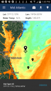
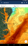
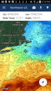
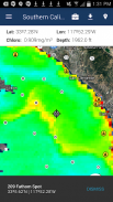
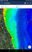
FishTrack onlar balık bulmak için gereken her şeyi tuzlu su balıkçıya sağlar. FishTrack uygulaması ücretsiz cloudfree deniz yüzeyi sıcaklığı (SST) grafikleri, küresel uydu görüntülerini ve deniz hava tahminleri sunar - hepsi tek katmanlı aracı.
yapabilirsiniz FishTrack ile:
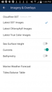
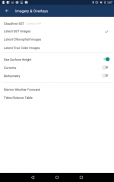
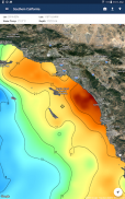
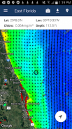
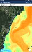
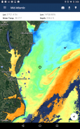
- En son SST, klorofil ve gerçek renk uydu görüntülerine bakın
- Yerleşimi bathymetry, okyanus akıntıları ve deniz yüzeyi yüksekliği
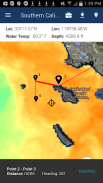
- Balıkçılık noktalar ve yakalar işaretlemek için yol işaretleri kaydet
- Bir gezi ve görünümü mesafeleri ve başlıklar planı yolları oluşturun
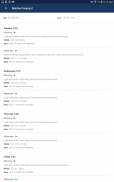
- Profil deniz hava tahminleri ve gelgit / solunar tablolar
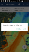
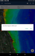
- Çevrimdışı kullanım için balıkçılık grafik görüntüleri kaydetme
- Geçerli konumunuzu görüntüleyin hem çevrimiçi hem de çevrimdışı
Kör balık yok! FishTrack Eğer offshore verimli bir gezi planı yardımcı olur. daha az yakıt yakmak ve daha hızlı balık bulmak.
Senden duymak istiyoruz! Bize ne düşündüğünüzü bildirmek için bizim app aracılığıyla soru veya görüş bildirmek. support@fishtrack.com: Eğer müşteri hizmeti takımımız ile doğrudan konuşmak isterseniz, bize e-posta gönderin.
FishTrack provides saltwater anglers with everything they need to find fish. The FishTrack app offers free cloudfree sea surface temperature (SST) charts, global satellite imagery and marine weather forecasts – all in one layered tool.
With FishTrack you can:
- View the latest SST, chlorophyll and true color satellite imagery
- Overlay bathymetry, ocean currents and sea surface height
- Save waypoints to mark fishing spots and catches
- Create routes to plan a trip and view distances and headings
- View marine weather forecasts and tides/solunar tables
- Save fishing chart imagery for offline use
- View your current location both online and offline
Don't fish blind! FishTrack helps you plan a productive trip offshore. Burn less fuel and find fish faster.
We want to hear from you! Submit your questions or comments through our app to let us know what you think. If you'd like to speak directly with our customer service team, please e-mail us at: support@fishtrack.com.